PRC Association
The Forest
Discovery Center
Premium Map / Book
Order our Waterproof Pigeon River Country Map and Book.
Discovery Center Mailing List
Upcoming Events
Hemingway’s Last Good Country: The Pigeon River Forest
A look at the influence Northern Michigan had on both Ernest Hemingway's personal life and literature through commentary and rare family photos provided by Christopher Struble, President of the Michigan […]
Birding and Forest Connection
Join experts Joy Mittig and Doug Reeves for a morning of forestry and birdwatching! The event starts with a presentation on forestry practices in the PRC and how they impact […]
Sinkhole Lakes
Sinkhole Regulations
The unique and fragile features of the lakes require special protections for boating and camping in their vicinity.
Please use the trails: All of the sinkhole lakes have footpaths around them, please do not climb the vertical walls surrounding the lakes. This unneccessary foot traffic will accelerate the erosion process.
Fishing: Refer to the Michigan Fishing Guide for additional information on seasons, rules, and regulations.
Camping: Special camping restrictions at some of these lakes. Review the State Land Use Orders for details.
Watercraft: Special boating restrictions at some of these lakes. Review the State Land Use Orders for details.
Swimming: Swimming and personal flotation tubes are permitted.
What is a Sinkhole Lake?
One of the special and unique features of the PRC is its sinkhole lakes.
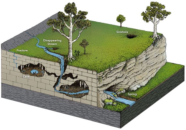
Sinkholes are usually, but not always linked with Karst landscapes. Karst refers to a topography shaped by soluble layers of bedrock like limestone and shale. Karst terrains are characterized by caves, steep valleys, sinkholes, and a general lack of surface streams because drainage is underground. A karst landscape has springs, sinking streams, caves, and sinkholes.
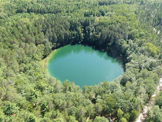
Aerial view of Lost Lake, courtesy of Luke Datema; Datema Media
A sinkhole, also known as a sink, shake hole, swallow hole, swallet, doline or cenote, is a natural or unnatural depression or hole that begins with underlying bedrock of limestone and shale. This area of NE Lower Michigan is made up of limestone and shale which was laid down between 345 and 395 million years ago, in the Devonian Period. The upper most layer of bedrock consists of limestone of the Traverse Group.
Sinkholes are formed by the dissolution of the soluble rocks, limestone and shale which are easily dissolved by acid water and is eroded into what is known as “karst” formations, which often contain underground streams and subsurface limestone caves.
When the limestone is dissolved by slightly acidic water, often an underground river aided by rainfall, it carves out large caves and caverns in the limestone. Some of these caves collapse in on themselves creating the sinkholes that are located here at the PRC.
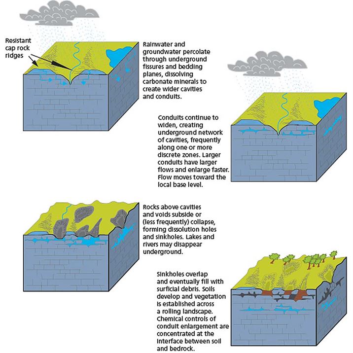 Courtesy of Trista L. Thornberry-Ehrlich (Colorado State University) with information from Hack (1974).
Some sinkholes are deep depressions, sometimes found in a line where an underground stream flows beneath. Such are the dry sinkholes just east of Shoepac Lake a few miles south of Onaway. Others, where the bottom of the sinkhole becomes plugged with marl or other less permeable material, form lakes like the ones here in the PRC. The PRC sinkhole lakes are sustained by underground springs.
Many mechanisms can form sinkholes including the slow removal of soluble bedrock (such as limestone) by underground water, the collapse of a cave roof, or when there is a natural (or unnatural) lowering of the water table. Occasionally a sinkhole may form in urban areas from human activity when a sewer line collapses or from a water main break.
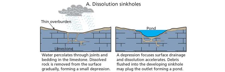
 Source: Ohio Department of Nature Resources, division of Geologic Survey.
Of the seven sinkhole lakes in the PRC, six of them are of the classical round sinkhole type with very steep banks. These six are: Devil’s Soup Bowl (the smallest of the lakes), Lost Lake, North and South Twin Lakes, Section Four Lake and West Lost Lake. The water of these six is typically milky blue-green. That is because they are reflecting their dissolved limestone origins and are fed mostly by underground springs. Hemlock Lake, while it has the typical steep bank along its eastern and southeastern shore, has some more gradual, even swampy shores. The depths of these lakes range from 30 to 60 feet, quite unusual for such small lakes in country with such sandy or gravelly soil.
The processes of dissolution, where evaporite rock (salt, gypsum, and anhydrite) that are soluble to weak acids, are dissolved, and suffusion, where cavities form below the land surface, are responsible for virtually all sinkholes in Michigan.
Dissolution Sinkholes
Source: Tihansky, A. B. 1999. Sinkholes, west-central Florida. US Geological Survey, Tampa, Florida.
Dissolution of the limestone or dolomite is most intensive where the water first contacts the rock surface. Aggressive dissolution also occurs where flow is focused in preexisting openings in the rock, such as along joints, fractures, and bedding planes, and in the zone of water-table fluctuation where groundwater is in contact with the atmosphere.
Rainfall and surface water percolate through joints in the limestone. Dissolved carbonate rock is carried away from the surface and a small depression gradually forms. On exposed carbonate surfaces, a depression may focus surface drainage, accelerating the dissolution process. Debris carried into the developing sinkhole may plug the outflow, ponding water and creating wetlands.
Discovery Center
Hours
Open the last weekend of April to the last weekend in October.
Sat: 10:00am - 4:00pm
Sun: 12:00pm - 4:00pm
Contact Us
![]()
![]()